One design wind speed citywide; the shoreline difference is exposure, not speed
The 2022 New York City Building Code prints a single basic design wind speed for every house in the five boroughs, and the one thing it does draw differently along the Staten Island shore is the exposure category — a separate variable, about the ground upwind of a site rather than about the wind over it.
This is an independent reference. It is not a contractor, it sells nothing, it inspects nothing and it refers no one, and nobody associated with it has installed a roof, hired a roofer or stood on a shoreline block with an anemometer. Nothing here is an inspection or a determination about your building, and in particular nothing here assigns an exposure category to any address — that determination belongs to a New York State registered design professional. The construction code governing this page is the 2022 New York City Construction Codes, effective November 7, 2022, with Chapter 15 as amended by Local Law 77 of 2023, effective June 10, 2023. New York City does not use the International Residential Code, and the wind provisions and section numbers in nationally written roofing material do not apply here.
Applies to
Detached Semi-detached Attached Two-family Low-slope rear extension Party-wall parapet
Every chip is filled because exposure is a property of the site rather than of an assembly. Section 1609.4 of the 2022 New York City Building Code attaches the category to the ground around a building, so it reaches the pitched planes, the flat rear extension and the parapet alike, and it does not change when only one of them is worked on.
Key figures
- Basic design wind speed, one- or two-family house
- 117 mph ultimate 3-second gust at 33 ft above ground, Exposure Category C, Risk Category II
- § 1609.3, Table 1609.3 2022 NYC Building Code VERBATIM [BC 1609.3]
- Separate coastal design wind speed
- None the table has four rows, one per Risk Category, and no geographic entry of any kind
- § 1609.3, Table 1609.3 2022 NYC Building Code VERBATIM [BC 1609.3]
- Exposure C shoreline band, heavy dashed symbol
- 2,600 ft “Buildings within a distance of 2,600 feet from shoreline”
- Fig. 1609.4.3, legend 2022 NYC Building Code VERBATIM [BC Fig 1609.4.3]
- Exposure C shoreline band, heavy solid symbol
- 2,600 ft or 20 × h “within a distance of 2,600 feet or 20 times building height from the shoreline, whichever is greater”
- Fig. 1609.4.3, legend 2022 NYC Building Code VERBATIM [BC Fig 1609.4.3]
- Exposure D, required upwind fetch
- 5,000 ft or 20 × h of Surface Roughness D prevailing upwind, whichever is greater; also within 600 ft or 20 × h of such a condition
- § 1609.4.3 2022 NYC Building Code VERBATIM [BC 1609.4]
- Allowable-stress-design conversion
- Vasd = 0.79V Equation 16-40; the conversion that produces the entry column of the shingle-classification table
- § 1609.3.1 2022 NYC Building Code VERBATIM [BC 1609.3]
 1
2
3
1
2
3
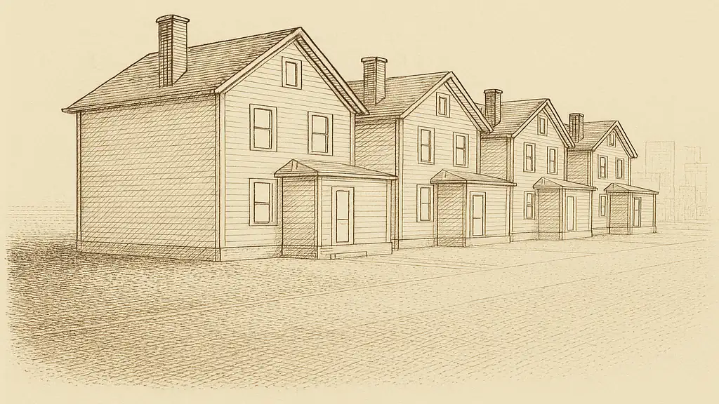
- The open, flat ground plane running to the horizon — what the code describes as Surface Roughness D, “flat, unobstructed areas and water surfaces” § 1609.4.2, 2022 NYC Building Code
- The run itself — “numerous closely spaced obstructions having the size of single-family dwellings or larger,” which is Surface Roughness B in the same section § 1609.4.2, 2022 NYC Building Code
- Further built form beyond the run — the same roughness continuing, which is what the words “prevails in the upwind direction” are asking about § 1609.4.3, 2022 NYC Building Code
Table 1609.3 prints one wind speed for each Risk Category and no geography at all
2022 ED. · CH. 16 STRUCTURAL DESIGN Section 1609.3 of the 2022 New York City Building Code says only that “the basic design wind speed, V, in mph, for determining wind speed shall be that of Table 1609.3”[BC 1609.3]. The table has four rows. They are indexed by Risk Category, which is a statement about what a building is used for and how many people are in it, and not by borough, ZIP code, distance from water or elevation.
| Risk Category | Basic design wind speed V, mph | Mean recurrence interval, years | Probability of exceedance in 50 yr, % |
|---|---|---|---|
| I | 110 | 300 | 15 |
| II — a one- or two-family house | 117 | 700 | 7 |
| III | 127 | 1700 | 3 |
| IV | 132 | 3000 | 1.6 |
| The code’s own note under the table: “Values are ultimate design 3-second gust wind speeds in miles per hour at 33 feet (10 058 mm) above ground for Exposure Category C.” VERBATIM [BC 1609.3] | |||
Three things follow from that note. The 117 mph is an ultimate 3-second gust, a design basis rather than a forecast and not a speed at which anything is expected to fail[BC 1609.3]. It is stated at a reference height of 33 ft, not at the height of a particular roof. And it is stated for Exposure Category C, so the table’s value is already tied to one assumed ground condition, from which the calculation adjusts to the actual one.
Section 1609.3.1 supplies the conversion to the older allowable-stress convention: Vasd = 0.79V, Equation 16-40[BC 1609.3]. That is the arithmetic behind the 94 mph row of the shingle-classification table in Chapter 15, which is where a homeowner’s version of this question ends up.
What is not in Table 1609.3 is any coastal row. There is no South Shore number, no waterfront number and no Todt Hill number. A contractor, an estimate or an advertisement that says a shoreline house is designed for a higher wind speed than an inland one is describing a document that does not exist in this city.
Exposure is a statement about the ground upwind of a site, and it is settled direction by direction
The variable that does change across the borough enters at section 1609.4 of the same edition, and the sentence that defines it is worth reading slowly, because almost every word in it is doing work.
“For each wind direction considered, an exposure category that adequately reflects the characteristics of ground surface irregularities shall be determined for the site at which the building or structure is to be constructed. Account shall be taken of variations in ground surface roughness that arise from natural topography and vegetation as well as from constructed features.”
For each wind direction considered. A building does not have an exposure category; it has one per direction, and a south-shore house can face open water one way and four hundred neighbouring houses the other. Ground surface irregularities. The subject of the sentence is the ground, not the air. Natural topography and vegetation as well as … constructed features. Buildings count as roughness; so do trees.
Section 1609.4.2 then defines three surface roughnesses, verbatim: Surface Roughness B is “urban and suburban areas, wooded areas or other terrain with numerous closely spaced obstructions having the size of single-family dwellings or larger”; Surface Roughness C is “open terrain with scattered obstructions having heights generally less than 30 feet (9144 mm),” including “flat open country, grasslands, and limited water surfaces per Figure 1609.4.3”; Surface Roughness D is “flat, unobstructed areas and water surfaces,” including “smooth mud flats, salt flats and unbroken ice”[BC 1609.4]. Section 1609.4.3 converts a roughness into a category by asking how far that roughness runs upwind: Exposure D applies where Surface Roughness D “prevails in the upwind direction for a distance of at least 5,000 feet (1524 m) or 20 times the height of the building, whichever is greater,” and also where the roughness immediately upwind is B or C but the site is “within a distance of 600 feet (182.9 m) or 20 times the building height, whichever is greater, from an Exposure D condition”[BC 1609.4].
Read plainly: the second half of that sentence is a proximity rule. A site does not have to sit on open water to be in Exposure D. It has to sit close enough to a stretch of open water that is itself long enough.
The city publishes five shoreline exposure sheets as Figure 1609.4.3, and sheet (5) is Staten Island
Section 1609.4.3 opens by stating that “Figure 1609.4.3 provides the exposure categories at the shore lines for wind directions approaching over the water within the city boundaries”[BC 1609.4]. The figure is not a paragraph of text. It is a set of five drawn sheets, one per borough, and they sit on pages 29 to 33 of the Chapter 16 PDF the Department of Buildings publishes: (1) Manhattan, (2) Bronx, (3) Brooklyn, (4) Queens and, on page 33, sheet (5), titled NEW YORK CITY WIND EXPOSURE: STATEN ISLAND SHORELINE[BC Fig 1609.4.3].
This is the part of the answer that is genuinely local, and it is almost absent from roofing writing about this borough. Its legend has exactly three symbols.
| Symbol drawn on the sheet | Legend text | Provenance |
|---|---|---|
| Heavy dashed line | “Exposure C: Buildings within a distance of 2,600 feet from shoreline.” | VERBATIM |
| Single heavy solid line | “Exposure C: Buildings within a distance of 2,600 feet or 20 times building height from the shoreline, whichever is greater.” | VERBATIM |
| Double line, two parallel rules | “Exposure D: Coastal zone, see Section 1609.4.” | VERBATIM |
| Legend text transcribed from sheet (5) of Figure 1609.4.3, page 33 of the 2022 New York City Building Code Chapter 16 PDF. The symbols themselves are drawn lines and are reproduced here by description, not redrawn. [BC Fig 1609.4.3] | ||
A reading of the drawing, not a statement of the code
What follows is what the symbols look like when the sheet is opened and enlarged, and it is set apart because it is an interpretation of a raster drawing rather than a sentence anyone published. Read at 220 dpi, the east and south shore of the borough carries the double line — the Exposure D coastal zone, running more or less continuously from around St. George and the Narrows south past Stapleton, Arrochar, Dongan Hills, South Beach, New Dorp and Great Kills, with a separate loop around Great Kills Harbor, and on past Eltingville, Huguenot and Wolfe’s Pond Park to the point at Tottenville. The north shore, from Shooter’s Island through Port Richmond to St. George, facing the Kill Van Kull, and the west shore along the Arthur Kill from Tottenville through Charleston and Rossville to Travis, carry the heavy dashed symbol — Exposure C within 2,600 feet of the shoreline.
Those names describe where symbols were read on a drawing. They are not a boundary and they place no address inside or outside anything. Open sheet (5) yourself, find the water your block faces, and take the question of which category governs a specific site to a New York State registered design professional — section 1609.4 settles it per wind direction, and the figure alone does not.
For a house, the “whichever is greater” clauses reduce to three plain distances
One legend entry and both limbs of the Exposure D test are written as a fixed distance or twenty times the building height, whichever is greater. Twenty times the height governs only above a height that follows from the fixed distance itself.
| Clause | Fixed distance | Height at which 20 × h equals it | Provenance |
|---|---|---|---|
| Exposure C shoreline band, solid symbol | 2,600 ft | 130 ft | DERIVED |
| Exposure D, upwind fetch of Surface Roughness D | 5,000 ft | 250 ft | DERIVED |
| Exposure D, proximity to an Exposure D condition | 600 ft | 30 ft | DERIVED |
| Fixed distances are quoted from the legend of Figure 1609.4.3 and from § 1609.4.3 of the 2022 New York City Building Code. The third column is division, shown in the margin, and nothing else on this page rests on it. [BC Fig 1609.4.3] [BC 1609.4] | |||
2,600 ÷ 20 = 130 ft · 5,000 ÷ 20 = 250 ft · 600 ÷ 20 = 30 ft
A two-storey house is nowhere near 130 ft or 250 ft, so the first two rows resolve to the fixed distances every time. The third is the one to be careful with: 30 ft is not far above the mean roof height of a two-storey house with a gable, so which term governs there is a question about one building’s measured height, and no such number is known here.
Exposure D raises the pressure at the same wind speed, and no figure for how much appears on this page
The categories exist because wind slowed by several thousand feet of houses and trees arrives at roof height with less energy than the same wind arriving off open water. The design calculation carries that difference in a velocity pressure exposure coefficient, tabulated in ASCE 7, Table 26.10-1 — a document behind a paywall that was not opened for this page. So the direction of the effect is stated here and the size of it is not: no percentage, no multiplier, and no numeric comparison between a shoreline block and an inland one.
| Quantity | Difference between the two sites | Where it is settled |
|---|---|---|
| Basic design wind speed V | None — 117 mph at both | § 1609.3 and Table 1609.3, 2022 New York City Building Code VERBATIM |
| Row of Table 1504.1.1 that is entered | None — the Vasd 94 / V 117 row at both | § 1504.1.1 and Table 1504.1.1, 2022 New York City Building Code VERBATIM |
| Required asphalt shingle classification | None — ASTM D7158 Class G or H at both | Table 1504.1.1, 2022 New York City Building Code VERBATIM |
| Velocity pressure exposure coefficient | no figure: no primary source opened | ASCE 7, Table 26.10-1. Paywalled; not opened for this page. |
| Ratio of velocity pressure, Exposure C to Exposure D | no figure: no primary source opened | Follows from the coefficient above, and therefore from the same unopened table. |
| Cells marked —— had no primary source that this site opened. They are left empty rather than filled from secondary reporting. Both appear in the numbered list of what this page does not establish. | ||
The required shingle class is the same on the shore as inland, because the table that selects it is entered with a wind speed
Section 1609.5.2 of the 2022 edition covers roof coverings, and its second exception routes asphalt shingles out of Chapter 16 entirely: “Asphalt shingles installed over a roof deck complying with Section 1609.5.1 shall comply with the wind-resistance requirements of Section 1504.1.1”[BC 1609.5.2]. Section 1504.1.1, in Chapter 15 of the same edition, requires shingles to be tested to ASTM D7158, an uplift force and uplift resistance method, and to meet the classification in Table 1504.1.1 “for the appropriate maximum wind speed.” The same section requires that “asphalt shingle packaging shall bear a label to indicate compliance with ASTM D 7158 and the required classification”[BC 1504.1.1].
Table 1504.1.1 is entered with two columns, a maximum allowable stress design wind speed and a maximum basic design wind speed from Table 1609.3. Exposure category does not appear in it. At V = 117 mph the required classification is ASTM D7158 Class G or H, and for shingles outside that standard’s scope, ASTM D3161 Class A, D or F[BC 1504.1.1]. That is the answer on the water and four miles inland, and it is checkable on the bundle wrapper in a driveway before the first course goes down.
A reader checking that section number against an older source will not find it. In the 2014 New York City Building Code the same requirement sat at § 1507.2.7.1 with Tables 1507.2.7.1(1) and (2)[BC 2014 1507.2.7.1]. Chapter 15 was renumbered in the 2022 edition, and a great deal of New York City roofing material in circulation still uses the old numbers.
There is a real tension between that chain and the exposure sheet, and it is not resolved by buying a different wrapper. The National Roofing Contractors Association, writing on the two shingle wind standards, states that ASTM D7158’s testing and calculation procedures “assume asphalt shingles are applied to buildings located in Exposure Categories B or C, having mean roof heights not exceeding 60 feet and no topographic wind speed-up effects,” that the classifications exclude Ground Roughness D and heights above 60 feet, and that designers should “use ASTM D7158 cautiously”[NRCA 2021]. The category the city’s own figure draws along the east and south shore is precisely the one the standard’s classification assumptions exclude. The code requires the label; the label’s underlying method does not claim to cover that ground condition. The same association records that the other shingle wind standard, ASTM D3161, states in its own text that “results of this test do not directly correlate to wind speeds experienced in service”[NRCA 2018]. Where the gap matters, the remedy is an engineered attachment specified by a design professional, not a different number printed on a bundle; the wind-class page linked below sets out what the two standards do measure.
A repair on a shoreline block is governed by the same provisions as a replacement, and exposure is not a reason to choose one
Nothing in section 1609.4 or in Figure 1609.4.3 is a condition assessment. The exposure category of a site is the same the day before a roof is repaired and the day after it is replaced, and it was the same for every year the existing covering stayed on. It is an input to a design calculation, not a finding about the roof that is there.
That matters because “you are in the coastal zone” is available as a sales sentence, and the documents behind it support no recommendation to replace anything. A repair of a wind-damaged area — replacing the lifted courses, re-nailing to the fastener requirements of section 1507.2.6 and the attachment minimum of section 1507.2.7 of the same edition — is governed by the same wind provisions as a full replacement, and is not made non-compliant by the site being near water. What decides between repair and replacement is a set of findings about the existing roof, which the tear-off page linked below sets out from the code. Where a covering is being replaced anyway, exposure is a reason to have the attachment specified rather than assumed.
The borough’s best-known storm was not a wind event, and the wind record here is thin
Anyone reading about coastal exposure here will meet Hurricane Sandy, and the National Hurricane Center’s tropical cyclone report on it can be opened. Its Staten Island material is overwhelmingly about water: a 9.56 ft storm surge and a 14.58 ft storm tide above mean lower low water at Bergen Point West Reach, and a prevalent inundation of 4–9 ft above ground level for Staten Island and Manhattan[NHC Sandy].
The measured winds are the part usually left out. The report’s surface observation tables give peak gusts on Staten Island of 64 kt, about 74 mph, at P.S. 32 in Gifford, flagged as an incomplete record; 59 kt, about 68 mph, at P.S. 53 in Bay Terrace, also incomplete; and 48 kt, about 55 mph, at the Bergen Point gauge at 9.1 m height[NHC Sandy]. Those sit well below the 117 mph ultimate design gust. There is no long-period first-order National Weather Service station in Richmond County, so no record gust for the borough is printed here either.
82.2% of the units in Richmond County are in one- or two-family structures, 25.5% are one-unit attached, and the median unit was built in 1974[ACS 2024]. A run of attached bays presents one continuous envelope to the same fetch, and the exposure a corner bay sees is not the exposure an interior bay sees.
What this page does not cover
This page covers two variables in the wind provisions of the 2022 New York City Building Code — the basic design wind speed and the exposure category — and the one figure the city draws for this borough. It calculates no wind load, velocity pressure or component-and-cladding pressure, and prints no coefficient from ASCE 7. It assigns no exposure category to any address. It does not cover flood zones, storm surge, base flood elevation or any floodplain requirement, which are a different body of law with a different map, and it does not cover snow or rain loading, ice barrier, ventilation, low-slope drainage or parapet construction, all of which have their own pages. It prices nothing and names no contractor.
When a filing or a licensed professional is actually required: exposure category is an input to a structural design, and a design is the work of a New York State registered architect or professional engineer. Which category governs a site, and what attachment is required for a covering there, go to one of them. A reroof that stays above the deck or sheathing requires no Department of Buildings permit under 1 RCNY § 101-14, Table 2, item IV.1; one that replaces the deck or sheathing does, under item IV.2, and structural work is filed regardless of what the roof covering does.
What this page does not establish
- The velocity pressure exposure coefficient at any height, and therefore the ratio between Exposure B, C and D pressures at the same wind speed. The values are tabulated in ASCE 7, Table 26.10-1, which is paywalled and was not opened. Opening it would settle the question; until then no percentage or multiplier is published here.
- Which exposure category applies at any particular address. Section 1609.4 of the 2022 New York City Building Code settles it for each wind direction from the ground upwind in that direction, which a figure read at borough scale cannot do. A determination by a New York State registered design professional would settle it for one site.
- Where, precisely, the symbols on sheet (5) of Figure 1609.4.3 change. The sheet is a raster drawing without coordinates, and the names used above describe where symbols were read on it rather than a boundary anyone published. A georeferenced or vector version issued by the Department of Buildings would settle it.
- What follows, in New York City, from ASTM D7158’s classifications excluding Ground Roughness D. The exclusion is stated by the National Roofing Contractors Association; the code routes shingles to the standard at § 1609.5.2 Exception 2 and § 1504.1.1 without qualifying it by exposure. A Department of Buildings determination would settle whether anything additional is required in that gap.
- An all-time peak wind gust of record for a Staten Island station. There is no long-period first-order National Weather Service station in Richmond County, and the highest primary-sourced measurement found is the 64 kt gust at P.S. 32 in Gifford during Sandy, which the National Hurricane Center itself flags as incomplete. A long-period station record for the borough would settle it.
- Whether the mean roof height of a typical two-storey house here is above or below the 30 ft at which twenty times the height overtakes the 600 ft proximity distance in § 1609.4.3. The threshold is arithmetic on a quoted number; the heights are not, and no measured distribution of mean roof heights for this stock was opened.
Sources
- [BC 1609.3]
- New York City Department of Buildings. 2022 New York City Building Code, Chapter 16 — Structural Design, § 1609.3 and Table 1609.3 (basic design wind speed); § 1609.3.1 and Equation 16-40 (wind speed conversion). https://www.nyc.gov/assets/buildings/codes-pdf/cons_codes_2022/2022BC_Chapter16_StructuralDesignWBwm.pdf
- [BC 1609.4]
- New York City Department of Buildings. 2022 New York City Building Code, Chapter 16 — Structural Design, § 1609.4 (exposure category), § 1609.4.2 (surface roughness categories B, C and D) and § 1609.4.3 (exposure categories, including the 5,000 ft and 600 ft Exposure D tests). https://www.nyc.gov/assets/buildings/codes-pdf/cons_codes_2022/2022BC_Chapter16_StructuralDesignWBwm.pdf
- [BC Fig 1609.4.3]
- New York City Department of Buildings. 2022 New York City Building Code, Chapter 16 — Structural Design, Figure 1609.4.3, five sheets on pages 29–33 of the chapter PDF: (1) Manhattan, (2) Bronx, (3) Brooklyn, (4) Queens, (5) New York City Wind Exposure: Staten Island Shoreline, page 33. Legend transcribed; symbol positions read from the drawing at 220 dpi. https://www.nyc.gov/assets/buildings/codes-pdf/cons_codes_2022/2022BC_Chapter16_StructuralDesignWBwm.pdf · Retrieved 2026-08-06
- [BC 1609.5.2]
- New York City Department of Buildings. 2022 New York City Building Code, Chapter 16 — Structural Design, § 1609.5.2 (roof coverings), Exception 2. https://www.nyc.gov/assets/buildings/codes-pdf/cons_codes_2022/2022BC_Chapter16_StructuralDesignWBwm.pdf
- [BC 1504.1.1]
- New York City Department of Buildings. 2022 New York City Building Code, Chapter 15 — Roof Assemblies and Rooftop Structures, as amended by Local Law 77 of 2023 (eff. 2023-06-10), § 1504.1.1 (wind resistance of asphalt shingles, and the packaging label requirement) and Table 1504.1.1 (classification of asphalt shingles). https://www.nyc.gov/assets/buildings/codes-pdf/cons_codes_2022/2022BC_Chapter15_RoofsRooftopsWBwm.pdf
- [BC 2014 1507.2.7.1]
- New York City Department of Buildings. 2014 New York City Building Code, Chapter 15 — Roof Assemblies and Rooftop Structures, § 1507.2.7.1 with Tables 1507.2.7.1(1) and 1507.2.7.1(2). Superseded edition, cited only to show where the requirement sat before the 2022 renumbering. https://www.nyc.gov/assets/buildings/codes-pdf/cons_codes_2014/2014CC_BC_Chapter_15_Roof_Assemblies_and_Rooftop_Structures.pdf
- [NRCA 2021]
- Graham, M.S. Understanding asphalt shingle standards, Professional Roofing (National Roofing Contractors Association), February 2021. ASTM D7158 classification assumptions and exclusions; D7158 and D3161 class speeds against the ultimate and allowable-stress conventions. https://www.professionalroofing.net/Articles/Understanding-asphalt-shingle-standards--02-01-2021/4817 · Retrieved 2026-08-06
- [NRCA 2018]
- Graham, M.S. The wind resistance of shingles, Professional Roofing (National Roofing Contractors Association), September 2018. ASTM D3161 method, durations and Class A, D and F speeds; the standard’s own statement that its results do not directly correlate to wind speeds experienced in service. https://www.professionalroofing.net/Articles/The-wind-resistance-of-shingles--09-01-2018/4302 · Retrieved 2026-08-06
- [NHC Sandy]
- Blake, E.S., Kimberlain, T.B., Berg, R.J., Cangialosi, J.P., and Beven II, J.L. Tropical Cyclone Report: Hurricane Sandy (AL182012), 22–29 October 2012, NOAA National Hurricane Center. New York narrative (Bergen Point West Reach surge and storm tide; prevalent inundation above ground level) and the surface observation tables (peak gusts at Staten Island P.S. 32 Gifford, P.S. 53 Bay Terrace and the Bergen Point gauge). https://www.nhc.noaa.gov/data/tcr/AL182012_Sandy.pdf · Retrieved 2026-08-06
- [ACS 2024]
- U.S. Census Bureau. American Community Survey, 2024 1-year estimates, Richmond County, New York (FIPS 36085), tables B25024, B25034 and B25037, retrieved through the Census Reporter API. censusreporter.org · Retrieved 2026-08-06